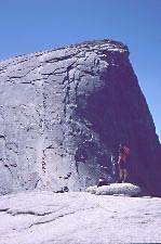
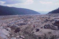
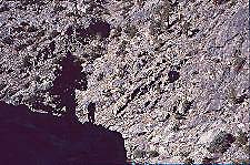
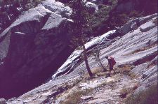
The cable onto Half Dome: Day 1, evening
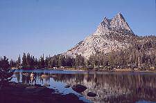
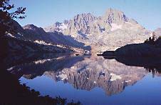
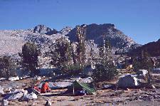
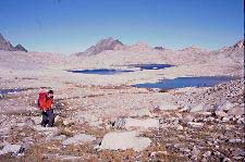
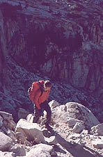
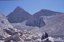
Cathedral Peak, Upper Cathedral Lake: camp, Day 2
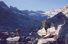
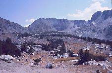
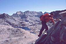
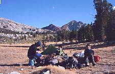
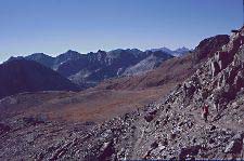
Approaching Donohue Pass early morning, Day 4
John Muir TrailRonald Turnbull : Thomas Turnbull : September 2007 |
|
My John Muir Book - including the John Muir Trail, the John Muir Way in East Lothian (Scotland), and John Muir the man - is on this website at Muir and More. For a podcast about walking the John Muir Trail and using Alan Castle's guidebook from Cicerone Press, go to www.backpackinglight.co.uk and search for 'Muir' or for 'Ronald'.
|
|
My son Tom started living in America in 2007, so it seemed like a good idea to go across and do the great American footpath. We'd left it late to book our permit, so ended up getting one in September 2007. This turned out to have several advantages: pleasanter temperatures, fewer folk around, and above all, no mosquitos. Half Dome isn't on the trail, but we went up Half Dome anyway. The ascent of the cables and wide-spaced wooden steps is as exciting as it looks in the picture. Late in the season, it wasn't too awkward passing the people coming down. Even so, the summit was quite a busy place. A couple of acres of flat stone, with a few mangled trees, and people wandering around looking over the edge in a bewildered sort of way. It was as if Trafalgar Square had been suddenly raised 5000ft into the air. Day 2: As we now had enough water, we diverted off the JMT trail again to cross Clouds Rest. This gave us great views back to Half Dome, and a little scrambling along the top. Plenty of trees, and some open meadows of yellow dry grass with granite crags above them, led to Cathedral Lake. more story or click a picture below |
|
The cable onto Half Dome: Day 1, evening |
Cathedral Peak, Upper Cathedral Lake: camp, Day 2 |
Approaching Donohue Pass early morning, Day 4 |
|
Cathedral Lake was cool but not cold, a bit muddy across the bottom, a great place to float about and gaze at the superb granite summit overhead. A photographer came to talk to us until he got so excited by the light that he had to start sticking his tripod into various bits of shoreline. I was excited by the light myself, but a bit embarrassed at my very small camera which didn't even have its exposure metre working properly. On this trail, one tends to discuss bears. And there are a lot of trees for them to be hiding behind, down 3000ft of zigzag trail to Tuolomne Meadow. Here we heard car engines among the treetrunks, though the JMT doesn't actually cross any tarmac in its entire 210 miles. We enjoyed a Tuolomne breakfast. It was only a moderately big breakfast, so when we'd finished it we had another one. Then we did our shopping. more story |
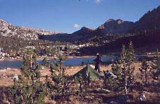
Donohue Peak, a side-trip from Donohue Pass, Day 4. Mounts Ritter and Banner behind. |
Mount Banner, and Garnet Lake, a really beautiful camp. Dawn Day 5 |
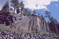
Devil's Postpile, above Red's Meadow: Day 5 |
|
Having enjoyed Cathedral Lake so much, we headed up to an even higher lake for the third night out (unnamed on our map, below Donohue Pass). Having reached the bleak stony Donohue Pass, we dumped the rucksacks and set off up the bleak stony Donohue Peak. The guidebook (by RJ Secor) had promised Class 2 scrambling, but it was a walk with some entertaining boulder-clambering to finish. The 1000ft of ascent above the pass took us to 12,000 ft and left us a bit breathless. But while the pass below gave bleak crag-hung views, the summit gave views of a different sort, distant spiky summits and rather a lot of lakes. This fourth day ended at a camp site of quite overpowering loveliness, alongside Garnet Lake. Trees and lakes led down to Reds Meadow, and the Devil's Postpile. In Japan it would be onsen, the natural hot pool set around with stone benches, alongside a pristine pre-wash zone and fluffy towels. At Red's, it's a concrete shower block. But the shower is a big whoosh of hot water, that never goes cold, and perhaps the Japanese do go to a whole lot of unnecessary bother. After all, there are plenty of tasteful aesthetic effects everywhere outside the shower hovel. more story |
Approaching Deer Lakes after diversion over Mammoth Crest Day 6 |
Duck Lake: still on the side-trip, Day 6 |
Edison Lake, crossed to Vermilion Resort: afternoon Day 7 |
|
We decided on another high level, and partly off-trail, diversion, over the Mammoth Crest. A mile of compass work through a pine forest: it's just orienteering, like we do in the woods at home. But somehow it seems more serious when, if we get it wrong, the forest goes on, and on, for several days of walking. However, we got it right. Here on Mammoth Crest is volcanic rubble, red crusty lava like clinker from a coal fire that burnt too hot. The larger black boulders have holes in like Emmental cheese, where the gasses boiled out of the molten rock. And all this only ten thousand years ago, which in geological terms is as recent as our last lunch-stop. The small path leads out to a large lake, where for two miles we romp down a well-made trail across a steep slope with the large lake (Duck Lake) at the bottom and an extremely shapely mountain rising on the other side. Below Silver Pass, the trail drops off excitingly into a granite hollow and then a whole lot of trees. Edison Lake had shrunk, due to a dry summer and also dam works. This gave us an another long hot mile across the dry lake bed to reach the speedboat that replaced the ferry. At the edge of the dried mud, we flopped out like stranded fish for half an hour till the boat came. Vermilion is one of the world's great walker stop-offs. It has a useful shop: but also a bear-proof barrel at the entrance where you can pick over other walkers' abandoned food before deploying your own credit card. Vermilion has all you can eat for about $10, and all you can eat is a lot. There are camp fires in old oil barrels under the stars, and benches around them. There are pre-erected bunk-bed tents, looking left-over from the Korean War, which you can sleep in if there's space. more story |
camp, Marie Lake, Day 8 |
scrambling to Mount Senger side-trip on Day 9 |
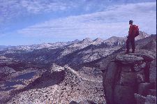
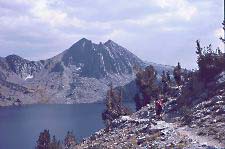
Mount Senger summit, to Marie Lake: Day 9 |
|
With the extra mud section, it turned out to be no shorter taking the ferry back to the trail than heading direct, up the Bear Ridge Trail. After a day of Bear Ridge and Bear Creek mostly under branches but happily bearless, we emerged to Marie Lake. The evening light caressed several ranges of pointy summits to the north-east. Next morning's side trip was Mount Senger. The guidebook made it a simple walk but we found a really enjoyable scramble on huge blocks of granite, a rising ridge that narrowed and steepened at the top and finished through a small hole. British Grade 2, I'd say, good big holds but quite steep and slightly exposed (ie with a drop below). Having had our scrambling fun, we headed down through more trees to Muir Trail Ranch. At Muir Trail, they're more interested in horses than in hikers. For $46 each they'd hauled in two plastic buckets full of food and stored them in their varmint-proof shed. It took two hours to pack it all into the bear barrels, find it wouldn't fit, decide what we were going to leave behind, and then pack it all in again. For several months I'd been wondering about the seven days of food. How far would we walk before it started being any fun again? Would we walk at all? We evaded the issue by putting some of the food back into the varmintproof shed for the night and heading out to the hot spring. more story |
San Joaquin canyon: Day 10 |
Just below Muir Pass, with Wanda Lake: Day 11 |
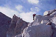
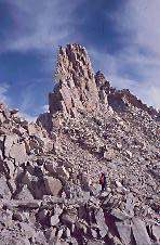
scrambling on Mt Solomons: Day 11 |
|
Next day we lifted on the heavy loads and found that we could walk after all. Because of the baggage this was to be a slow, short day. Sadly, that turned out to mean a day entirely uphill. But the San Joaquin valley surprised us by not being a path under some pines but an impressive canyon. And above was Evolution Basin, possibly the very best of all the high lakes surrounded by slightly sheltered camp sites and big big mountains.
The passes so far have been at around 11,000ft: now comes an abrupt jump up, with Muir Pass the first of the 12,000-footers. We diverted for another bit of hill climbing, so as a) not to be wearing the overloaded backpacks while meanwhile b) lightening them by a half-day's food. more story |
 | ||
| 700kB file: very slow without Broadband | Mount Solomons 36° panorama | opens in new window: bring old window to front during the boring wait |
|
The scrambling picture above is entirely misleading. Mount Solomons is a heap of rubble, and all the way up we were wondering whether it was going to come down and join us quicker than we could get up on it. But the view from the top repaid all. The Sierra Nevada are 200 miles of granite. Except that here and there you're on top of the big granite lump and in among the older and darker volcanic rocks it melted its way up into. (This shows rather well on Mt Goddard in the Mount Solomons 360° panorama). Descending from Muir Pass is a wonderful mix-up of pale granite and black basalt. The further descent was among and over granite slabs into Le Conte Canyon, where we camped in woods. The next bit is the celebrated 'Golden Staircase', described as a path engineered out of a solid rockface. It's actually just more zig-zags (or 'switchbacks' in US) but impressive anyway. Above is the Palisades Lake -- a bare-rock blue lake among big spiky mountains, lovely yes, but not that dissimilar from the ones I've already taken pictures of. Each of the eleven passes has its own style and character. Mather Pass, the second 12,000-er, is bleak as Muir was but more sudden, with a narrow ridgeline and abrupt drop to a crag-ringed moraine plain with small lakes. more story |
descending Muir Pass: Day 11 |
descending to Le Conte Canyon: Day 11 |
Golden Staircase to Mather Pass: Day 12 |
|
Next morning a short climb led us to our next pass, the Pinchot. As we approached popular Rae Lakes the trail got busier. Are the Rae Lakes the loveliest of all the pine-scattered, crag-surrounded, lakeside camp sites? more story |
Camp near Bench Lake Ranger Station: afternoon Day 12 |
Camp at lake near Bench Lake Ranger Station: evening Day 12 |
Descending Pinchot Pass: Day 13 |
|
Our routine is to rise at first light, 6am; enjoy a chilly and not very enjoyable breakfast; and hit the trail at 7am just as the sun rises. This lets us enjoy the cool of the day walking, cover 15 miles without any hurry and with a one-hour lunchstop for peanut butter crackers, and then enjoy several hours of the day's hot bit, lounging at some lakeside and eating supper. But for this long day we rose in the starlight at 5am, and hit the trail at first light. Glen Pass was a pile of multi-coloured rubble, with a weirdly striped mountain overhead, and (thankfully) the usual good path underfoot. Sunrise struck us at the pass top. Thus we had all morning for the long trek through the trees of (reputedly bear-infested) Bubbs Creek to the base of Forester Pass. High above and far away, jagged mountains closed off the valley head. The trail rose, the creek diminished, the trees became more sparse. The trail passed up through scrub, and lunch was a last green patch at a pool surrounded by stones. The trail zigzagged (or switchbacked) through stones to the sterile grey-blue lake below the triangle of Junction Peak, and then ever upwards among the great boulderfields (American 'talus') below the closing crags. A dozen final zig-zags led to the pass crest. 13,180ft is, for the cosmopolitan, just about 4020m -- at 13,000ft altitude it took me 15 minutes to make the calculation in my head. My first time at such height since Mont Blanc 35 years ago: Tom's first time ever. The descent from Forester is a really impressive crag-cut pathway with big drops below. A yellow-bellied marmot grabbed one of the sparse trailside plants and sat on a stone gnawing at it. It knew we were just going to grab its sparse plant but kept a suspicious eye on us so we couldn't. With a short, lazy Wednesday to Guitar Lake ahead, we lay in until 7am, and bumbled down the valley taking arty photos. Two hours later, an approaching hiker brought news from the Ranger Station. It's going to start snowing tonight, and the big storm is tomorrow morning. We are between the 13,000ft Forester Pass and the 13,5000ft Trail Crest pass that's alongside Whitney summit. And although I have insurance against being rescued by helicopter, Tom doesn't. We walked rather fast and didn't stop for lunch. Wispy cirrus came up from behind us and started filling the sky. The ranger at the ranger station said that the snow wasn't going to start until tomorrow; but on the other hand, it was windy gusting 50mph on Whitney summit right now. We came out of the trees to Guitar Lake. Back in the north, we could see the mountains gathering cloud around their summits. Overhead, the cirrus covered the sky, and the thicker stratus was creeping up behind it. Long, long switchbacks lead up the craggy side of Mt Whitney to the trail junction below the Trail Crest pass. 4pm was the last sensible time. It was, at this moment in time, 3pm. Heading up Whitney wasn't merely possible. It was actually the sensible thing to do. The ridge to Whitney is narrow and rocky, with huge vertical drops on the Lone Pine side but drops that are merely steep and fairly huge on the west side where we were. We set off up the terraced path. An hour after everyone else had left it, we reached the summit of Mount Whitney. more story |
Junction Peak, below Forester Pass: Day 14 |
Trail below Muir Peak, summit ridge of Mt Whitney: Day 15 |
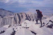
Whitney summit |
|
6000ft of downhill all at once can be extremely trying, when you're tired and have sore and damaged feet. But after 15 days of dry socks all the time, our feet were fine; and we were feeling fit. Indeed, we had that feeling of going on strongly, and being ready to go on going strongly, which is ultimately an illusion that can collapse suddenly but is very pleasurable while it lasts, and for us it lasted until nightfall. At which point we cosily camped at about the 10,000ft level (Outpost Camp) in sheltering trees and well below the windswept stony zone. Next morning, as we trekked gently down to the car park, the first pretty little snowflakes fell onto the path. Far back above, Mt Whitney was white screeslopes running up into swirly cloud. But actually (whisper it softly) the JMT is a path that's outstandingly beautiful; that gives good company along the trail; that among the granite has some stimulatingly visible geology -- but is slightly too pleasant and straightforward. That last long day added necessary excitement and energy. And with all that excitement, we were a day ahead of ourselves. So we hired a car, and went to Death Valley. more story |
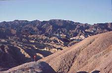
Zabriskie Point, above Death Valley: just after sunrise |
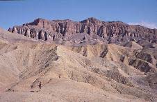
Red Cathedral, above Golden Canyon, Death Valley |
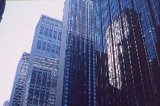
New York |
|
We used Alan Castle's guide The John Muir Trail published by Cicerone Press for valuable info about permits, transport, resupply, gear and so on: we didn't need to carry it on the trail itself because of the excellent Tom Harrison trail maps (John Muir Trail map pack at 1" to the mile). For peaks alongside, we carried photocopied pages out of The High Sierra: Peaks, Passes and Trails by RJ Secor ISBN 0 89886 625 1. The book is tremendously thorough and complete, but its account of easy scrambling peaks is a bit cursory. US Class 2,3,4 would appear to correspond with UK scrambling grades 1,2,3: Class 4 is approximately climbing grade Moderate -- so far as I can tell. Useful personal advice came from previous trail-goers Jeff Parr and Chris Townsend (who suggested the Mammoth Crest -- thanks for that, Chris). The webpage about my John Muir Book - including the John Muir Trail, the John Muir Way in East Lothian (Scotland), and John Muir the man - is on this website at Muir and More -- click it and see. We are: Thomas Turnbull, webdesigner in the environmental sector, currently residing in New York website Ronald Turnbull, outdoor writer, living in Dumfriesshire, Scotland homepage |
| top |